190021115026
Be quick - save $250.00
Shop By Category Drones and Aerial Imaging Drones DJI
Be quick - save $250.00
The DJI Air 3S Drone Fly More Combo offers enhanced nighttime flying with a forward-facing LiDAR sensor integrated into its safety systems. It features a dual-camera system with wide-angle and telephoto lenses, perfect for capturing landscapes and portraits. Compact and foldable, it's easy to transport. The package includes extra batteries and accessories for extended flight times and creative shooting options, while the smart remote and storage solutions enhance usability and convenience for capturing stunning aerial footage.
The DJI Air 3S Drone Fly More Combo offers a range of benefits that enhance your aerial photography and videography experience.
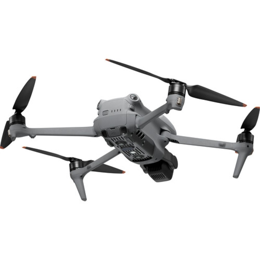
The forward-facing LiDAR sensor enhances night flying, filming, and safety by integrating with the APAS avoidance system and return-to-home function.
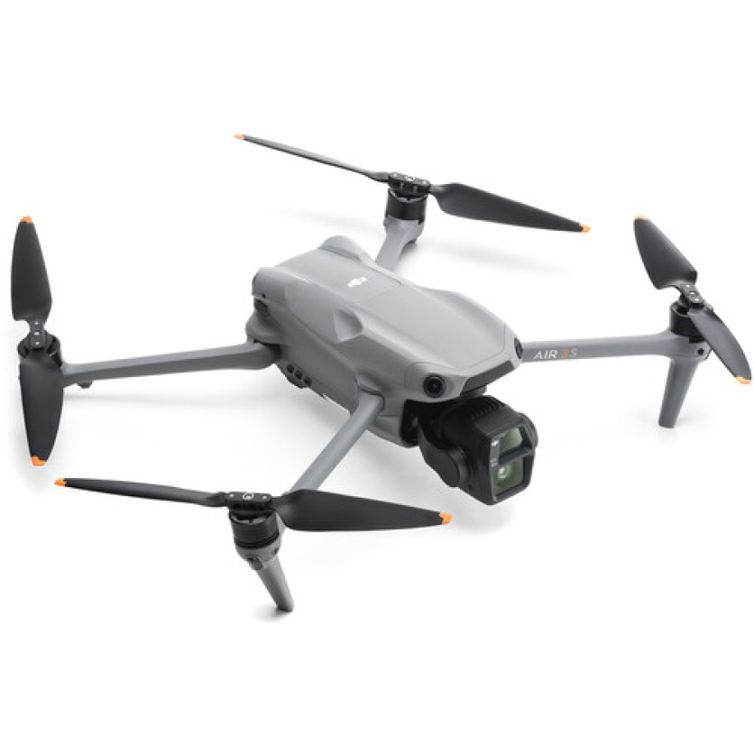
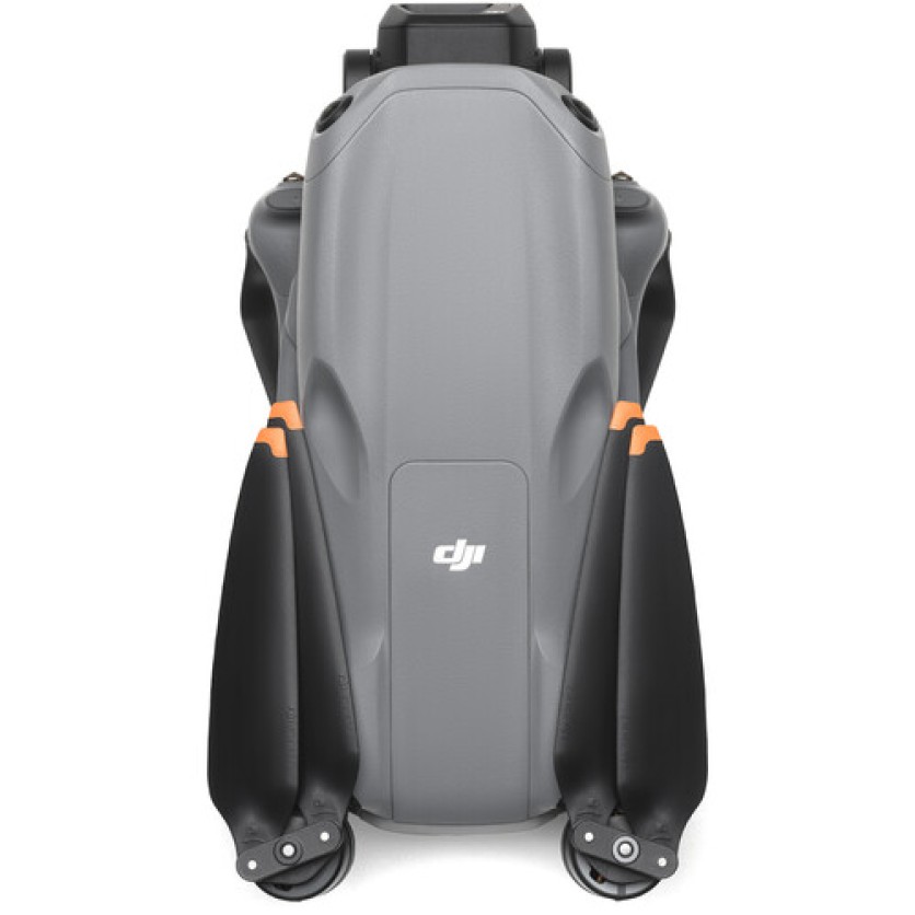
The dual-camera system provides a 24mm wide-angle and a 70mm telephoto lens, capturing landscapes and portraits with stunning clarity in both 4K60 HDR and 4K120 slow motion.
Enjoy a variety of shooting modes including 2.7K vertical shooting, MasterShots, QuickShots, and more, enabling dynamic and professional content creation.
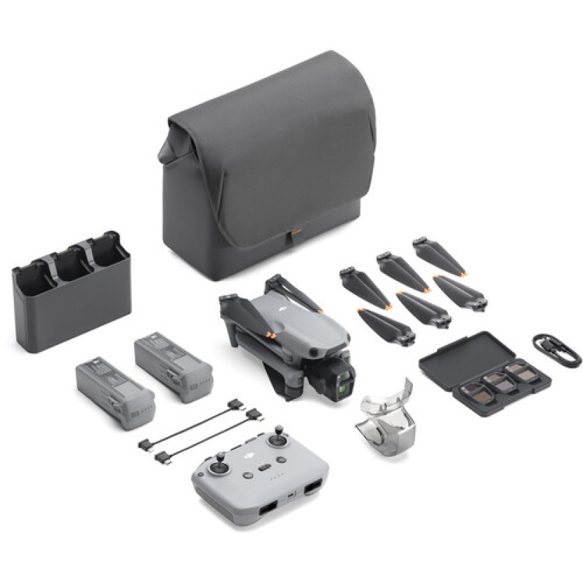
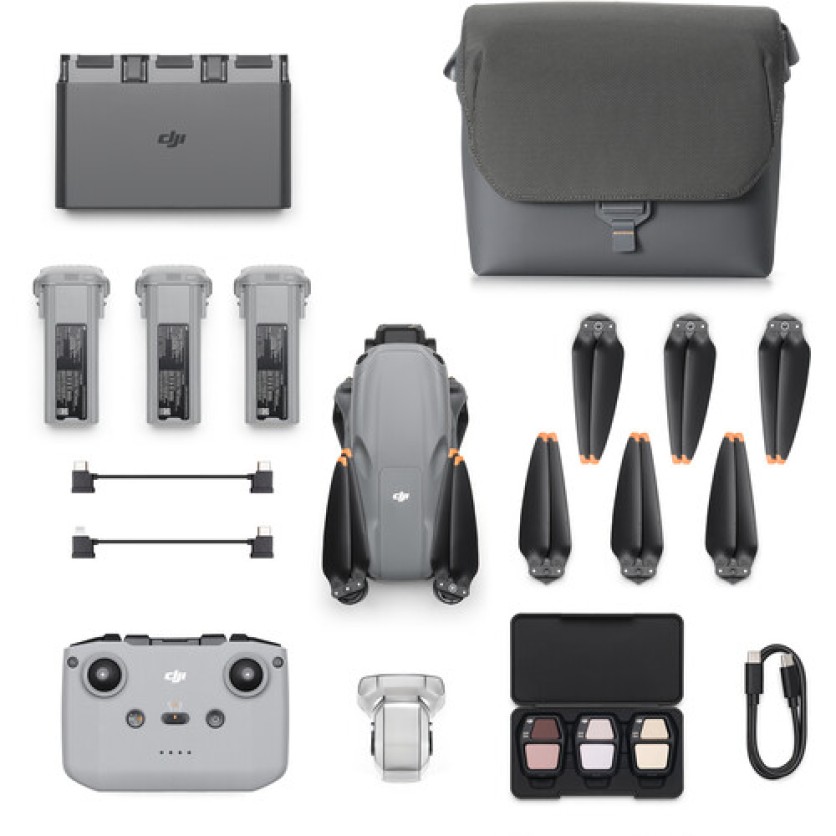
The Fly More Combo includes essential accessories like additional batteries, low-noise propellers, ND filters, and a shoulder bag, extending your flight time and convenience.
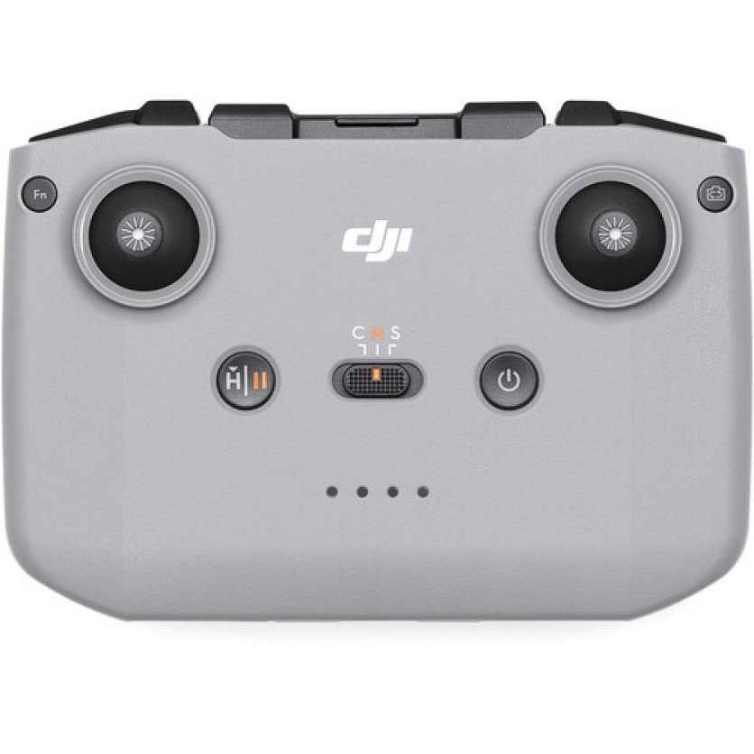
The RC-N3 remote controller, with smartphone integration, offers extended piloting time, while features like Smart RTH and Vision Assist ensure safe and efficient operations.
| Maximum Horizontal Speed | 47.0 mph / 21 m/s |
|---|---|
| Maximum Ascent Speed | 22.4 mph / 10 m/s |
| Maximum Descent Speed | 22.4 mph / 10 m/s |
| Maximum Wind Resistance | 26.8 mph / 12 m/s |
| Maximum Take-Off Altitude | 3.7 Miles / 6000 m |
| Maximum Flight Time | 45 Minutes |
| Maximum Hover Time | 41 Minutes |
| Maximum Tilt Angle | 36° |
| Hovering Accuracy | Vision Positioning: Vertical: ±0.3' / 0.1 m, Horizontal: ±1.0' / 0.3 m GNSS: Vertical: ±1.6' / 0.5 m, Horizontal: ±1.6' / 0.5 m |
| Rotor Configuration | Quadcopter |
|---|---|
| Aircraft I/O | 1x USB-C Input/Output (Data, Power) |
| Operating Conditions | 14 to 104°F / -10 to 40°C |
| Number of Cameras | 2 |
|---|---|
| Camera System | Wide: 50 MP, 1"-Type CMOS Sensor with 24mm-Equivalent, f/1.8 Lens (84° FoV) Medium Telephoto: 48 MP, 1/1.3"-Type CMOS Sensor with 70mm-Equivalent, f/2.8 Lens (35° FoV) |
| Digital Zoom | Wide: 1 to 2.9x Medium Telephoto: 3 to 9x |
| Minimum Focus Distance | Wide: 1.6' / 0.5 m Medium Telephoto: 9.8' / 3 m |
| ISO Sensitivity Range | Wide: Photo: 100 to 6400, Video: 100 to 12,800 Medium Telephoto: Photo: 100 to 6400, Video: 100 to 12,800 |
| Shutter Speed | Wide: 1/8000 to 2 Seconds (Photo) Medium Telephoto: 1/16000 to 2 Seconds (Photo) |
| Maximum Video Resolution | Wide: Up to UHD 4K at 120 fps / 1080p at 240 fps Medium Telephoto: Up to UHD 4K at 120 fps / 1080p at 240 fps |
| Still Image Support | Wide: Up to 12 MP (DNG / JPEG / Raw), Up to 50 MP (DNG / JPEG / Raw) Medium Telephoto: Up to 12 MP (DNG / JPEG / Raw), Up to 48 MP (DNG / JPEG / Raw) |
| Photo Modes | Auto-Exposure Bracketing (AEB), Burst Shooting, Interval, Single Shot |
| Media/Memory Card Slot | In Aircraft Body: microSD/microSDHC/microSDXC [512 GB Maximum / U3/V30 or Faster Recommended] |
| Internal Storage | In Aircraft Body: 42 GB |
| Number of Axes | 3: Pitch (Tilt), Roll, Yaw (Pan) |
|---|---|
| Rotation Range | Controllable Range: Yaw (Pan): 10° (-5 to 5°), Pitch (Tilt): 150° (-90 to 60°) Mechanical Range: Yaw (Pan): 54° (-27 to 27°), Roll: 100° (-50 to 50°), Pitch (Tilt): 205° (-135 to 70°) |
| Follow Speed | Tilt: 100°/s |
| Stabilization Accuracy | ±0.0037° |
| Sensing System | Omnidirectional with LiDAR Enhancement |
|---|---|
| Sensing System Capabilities | Forward: Measurement Range: 1.6 to 59.1' / 0.5 to 18 m, Detection Range: 1.6 to 656.2' / 0.5 to 200 m, Max Speed: 33.6 mph / 15 m/s, Field of View: 90° (Horizontal) / 72° (Vertical) Backward: Measurement Range: 1.6 to 59.1' / 0.5 to 18 m, Max Speed: 31.3 mph / 14 m/s, Field of View: 90° (Horizontal) / 72° (Vertical) Lateral: Measurement Range: 1.6 to 98.4' / 0.5 to 30 m, Max Speed: 31.3 mph / 14 m/s, Field of View: 90° (Horizontal) / 72° (Vertical) Upward: Measurement Range: 1.6 to 59.1' / 0.5 to 18 m, Max Speed: 13.4 mph / 6 m/s, Field of View: 72° (Front-to-Back) / 90° (Side-to-Side) Downward: Measurement Range: 1.0 to 45.9' / 0.3 to 14 m, Max Speed: 13.4 mph / 6 m/s, Field of View: 106° (Front-to-Back) / 90° (Side-to-Side) |
| Control Method | Included Transmitter with Smartphone/Mobile Device |
|---|---|
| Operating Frequency | 2.4 GHz (2.400 to 2.4835) 5.1 GHz (5.170 to 5.250) 5.8 GHz (5.725 to 5.850) |
| Maximum Operating Distance | 12.4 Miles / 20 km |
| Transmitter Power | 2.4 G: 33 dBm (FCC), 20 dBm (CE, MIC, SRRC) 5.1 G: 23 dBm (CE) 5.8 G: 33 dBm (FCC), 14 dBm (CE), 30 dBm (SRRC) |
| Transmitter I/O | 1x Lightning Input/Output (Data, Power) 1x USB-C Input/Output (Data, Power) 1x Micro-USB Input/Output (Data, Power) |
| Battery Type | Built-In Lithium-Ion (2600 mAh) |
| Mobile Device Compatibility | Devices up to 7.1" / 180 mm Wide and 0.4" / 10.2 mm Thick |
| Mobile App Compatible | Yes: Android & iOS |
| Operating Temperature | 14 to 104°F / -10 to 40°C |
| Battery Chemistry | Lithium-Ion |
|---|---|
| Battery Capacity | 4276 mAh / 62.5 Wh |
| Battery Configuration | 4 S / 14.6 V |
| Maximum Charging Power | 17.2 V |
| Charging Temperature | 41 to 104°F / 5 to 40°C |
| Weight | 8.7 oz / 247 g |
| Charger Input Power | 5 to 20 VDC at 5 A |
|---|---|
| Output Voltage | 5 V, 3 A 9 V, 5 A 12 V, 5 A 15 V, 5 A 17.2 V, 5 A 20 V, 4.1 A |
| GNSS Support | GPS, BeiDou, Galileo |
|---|---|
| Overall Dimensions | 4.0 x 3.5 x 8.4" / 100.6 x 89.2 x 214.2 mm (Folded) 12.8 x 4.2 x 10.5" / 325.5 x 106.0 x 266.1 mm (Unfolded) |
| Weight | 1.6 lb / 724 g (Takeoff) |